Monday, December 12, 2022

Mount Le Conte via Bull Head & Overnight

Smoky Mountains National Park
December 2 - 3, 202
2

What a trip! Mount Le Conte is my mountain of choice in the Smoky Mountain National Park since I first climbed it with my Friend Greg back in June of 2013. With this ascent, I now only have two more trails (Brushy Mountain and The Boulevard) and then I will have summited Mt. Le Conte by all routes. 


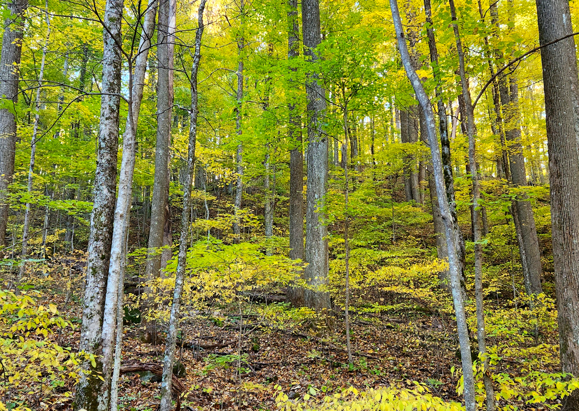
Trail Breakdown: 

Old Surgalands ..................... 0.4 Miles
Bull Head          ..................... 6.4 Miles
Rainbow Falls    ..................... 6.0 Miles* 

* You will see on my recording more miles were logged as I traversed the different sights up top. The next morning, I also had the 0.5 miles on Bull Head to get to the Rainbow Falls junction. My total logged trip was 17.3 miles. 

The plan for this trip was for me to ascend Bull Head for the first time, stay at the shelter, and then descend via Trillium Gap. To my knowledge, this would make the longest loop hike of Mt. Le Conte. I am going to have to try this again as I audibled at the last-minute Saturday morning due to time and descended via Rainbow Falls.  

While I have been down Bull Head a couple of times, once in full summer bloom and the second time in late fall when it recently re-opened after the Chimney Top Fire this was my first ascent. The day was cool, with partly sunny skies turning cloudy but an overall beautiful day do be out in the mountains. I parked and the Rainbow Falls parking area and headed down Old Sugarland's Trail to where it meets up with Bull Head and then started heading up. Right away the elevation gain was apparent, and I knew it was going to be a climb, especially with my overnight pack on.  

As I headed up you could still see all the devastation the fire created with dead trees, fire scored rocks, and deadfall everywhere. You need to be careful on this trail when the ground is wet with high winds because trees can come down easily in those conditions. Green is coming back with a lot of spruce trees popping up, but it will take a long time for the forest to get back to what it was. The fire conditions have created an opportunity for some magnificent views, and I found myself filming at taking pictures at almost every turn of the trail.  

Me Along the Bull Head Trail

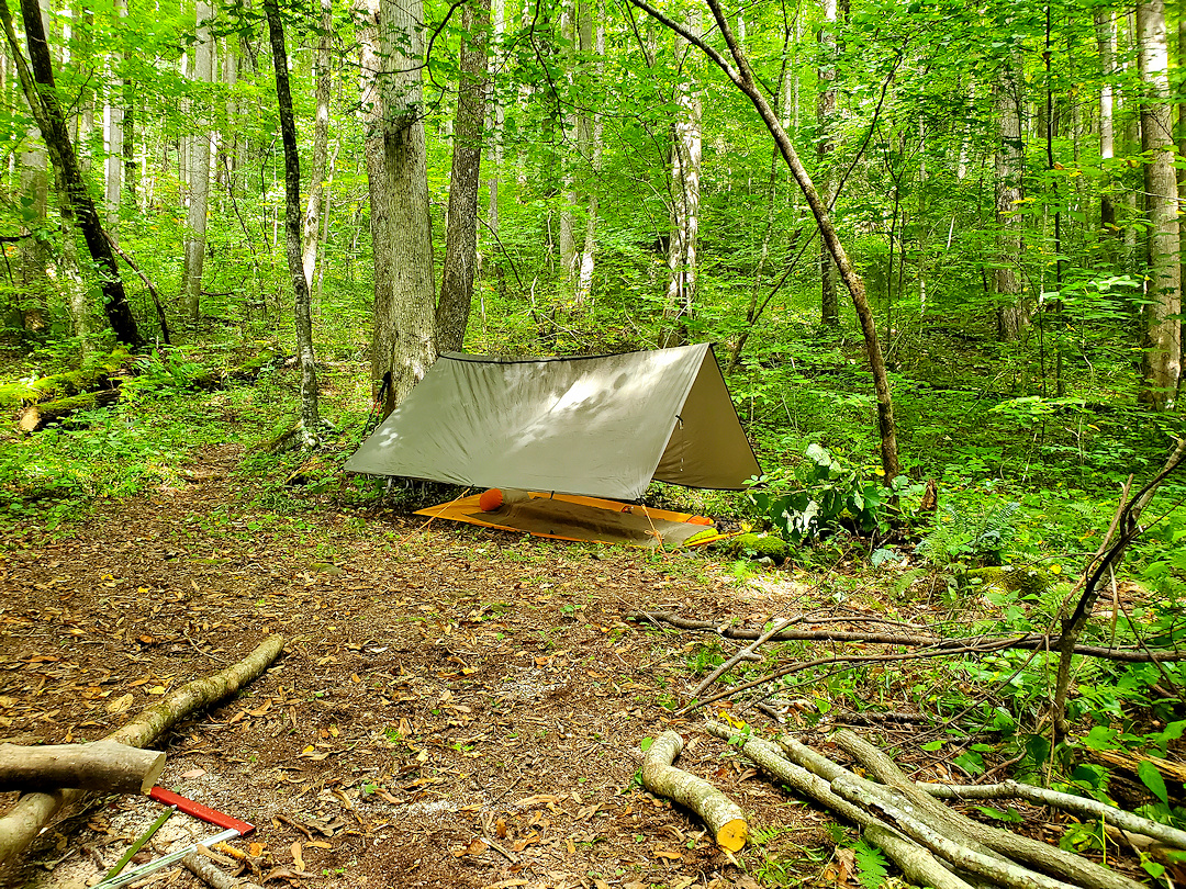
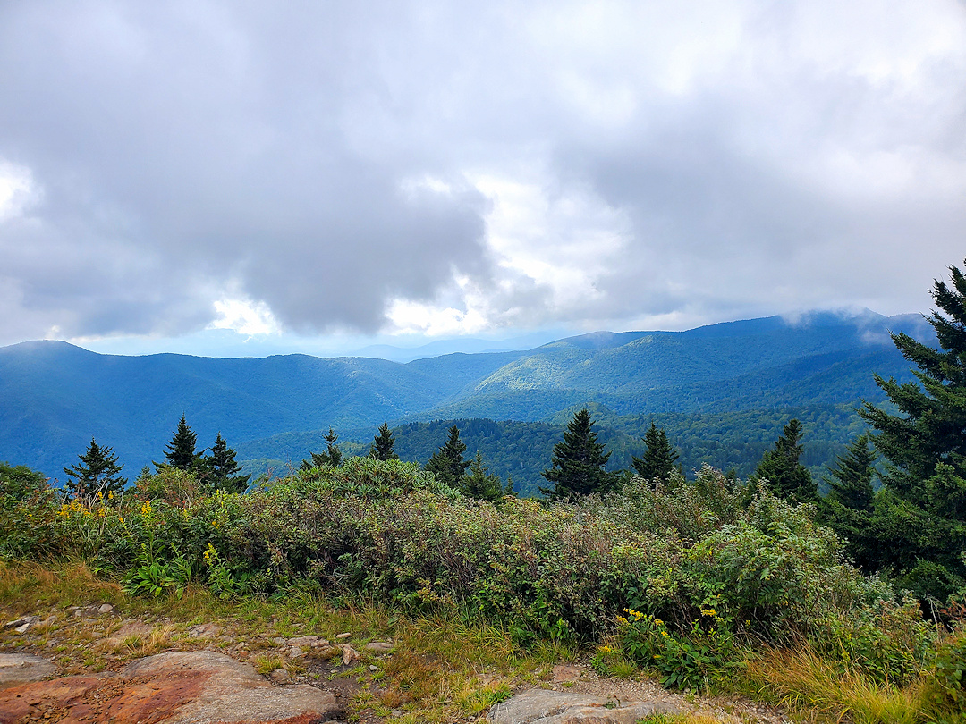
After about six miles on Bull Head, you come to the trail junction with Rainbow Falls then you have just over a half mile to reach the inn and shelter. That half mile is a tough climb, and I am not talking about trail obstacles, it is simply good old elevation gain. Passing the inn on my left, that is closed for the winter, I continued up the trail to the shelter on the right. The shelter houses twelve spots for people staying the night and you need to purchase a permit to stay there. When I purchased mine, it was the last one available for this date. To my surprise I was the first one there, so I picked a spot, and laid out my sleep kit.  

I stored my large backpack in the shelter and packed my cook kit, meal, snacks, and beverage in my haversack then head back out. The first spot I wanted to see was Hight Top that is the “true” summit of Mount Le Conte. You know you are there because people have stacked a huge pile of rocks on the location. It is surrounded by pine trees and there are not any significant views, but you must tag the top right?  

After High Top I kept heading up the trail to Myrtle Point which is at the section of the trail where Bull Head turns into the Boulevard. Take a side trail that is marked, and you will reach a rock outcropping with a fantastic view of Clingman’s Dome in the background. Myrtle Point is also the spot to see a Mount Le Conte sunrise, which I have yet to see. Hopefully, my next overnight I will get a clear morning.  

View at Myrtle Point


At this point I was losing daylight and was planning to have my dinner, beverage, and film a time lapse video over on Cliff Top. Cliff Top is another rock outcropping with a view of the Chimney Tops and is the spot for Sunsets. It is also close to the shelter, but I had to hoof it to get there with some daylight left. When I got there the view was good, but clouds were moving in, and the wind had picked up considerably. It was so windy I could not set the GoPro down on the tripod because the wind would just take it away. I tried holding it for a while but with the wind I could not even hold it steady. I figured I would never get water to boil for my meal, so I packed up and headed back to the shelter.  

When I returned to the shelter it was dark and not a sole was there. I saw a total of four people hiking down as I was going up, but it is a long loop no matter which way you go, and it was a Friday so that made since. Most come up the Alum Cave Trail because it is the shortest and I did hear a large group roaming around when I first got up there. I figured at least there would have been a few at the shelter but I would occupy it all to myself.  

The Bull Head Trail - Mount Le Conte
I boiled water for my food and had my beverage but soon it was dark, and I could no longer see unless I had my headlamp on. It was only 8:30 PM but I decided to pack in and hit the sleeping bag since there really was nothing I could do. I slept really well and was never cold even though the wind blew something fierce, and the rain started coming down around 3:00 AM. My Sleep system worked great and the three-season sleeping pad has been one of my best backcountry camping purchases I have made.  


I was awake around 5:00 AM still not being able to see anything, so I dosed on and off until about 7:30 AM then made some coffee. I made two cups and sampled a Black Riffle Coffee pouch and their instant coffee. Both were good though I think I might try two packages next time for the amount of water I used. I had my freeze-dried biscuits and gravy and tried to repack my gear to protect it from the rain the best I could.  

Finally hitting the trail around 10:00 AM and as I headed towards Trillium Gap I decided to turn around and descend via Rainbow Falls. My plan was to get started earlier and by taking this route it cut about four miles off my trip. The rain came down and I would walk through mist from time to time. I was now making good time as my track took me downhill and I did not see anyone on this side of the waterfall.  

When I got to Rainbow Falls I took my camera out to film as I approached but when rounding the last turn the falls were covered in a shroud of mist. Rainbow Falls is one of the most magnificent waterfalls in the park with it being one of my favorites to visit but it did not want its picture taken today. 

Me with Rainbow Falls in the background
The hike up to the falls is one of the parks most traveled trails so it was no surprise that I started running into quite a few people at this point coming up the trail. I felt a little sorry for them slugging through the rain and mud in nice clothes to get a picture at the waterfall only to not be able to see it when they get there. I also have come up with a hat idea, one that reads “Don’t ask me how much further!” as just about everyone heading up asked me.  


After another two and half miles I reached the Jeep, put on my dry clothes, and headed home for a well-deserved beer. This was a beauty of a hike and one if you are fit enough I would diffidently go and try it. Here in the near future, I plan to try the Bull Head / Trillium Gap loop, but I might go fast and light instead of staying the night. Not sure yet, but you can be sure I will let you know how it goes when I get it in. 

3D Rendering of my route via AllTrails

Story Links:

YouTube Video:


Thursday, November 10, 2022

Fall 2022 Frozen Head Hike

Frozen Head State Park
October 23, 2022  

I took Frank up to Frozen Head State Park for a fall hike and not going to lie it was one of the best fall hikes I have been on since moving to East Tennessee. The only one I would rate better was the Rich Mount Loop in the Smoky Mountains around the second year we moved down here. Today the weather was perfect with a slight breeze and crystal, clear blue skies. Since we have been in somewhat of a drought, the colors are not popping quite like usual, but they are still beautiful with most being a golden yellow with a few red ones worked in.  

When hiking in familiar locations I try to find new routes or tweak trails to make it a little different from previous hikes. On this hike I hit a new section of trail to make a loop just over ten miles. Below are the trails I hit to make this loop. 

(1)  North Old Mac …............ 3.55 miles 
(2)  West Lookout Tower …...  6.33 miles 
(3)  Flat Rock Story Book …... 0.45 miles  


The section of West Lookout Tower from North Old Mac to the Bird Mountain junction was a section I have not hit before. That section of the trail is not too bad and is part of an old dirt/gravel road with some pleasant views and nice places to stop and rest or snack. But the section that goes from the Bird Mountain junction to the campground is downhill with big rocks. That combination makes it really rough on the ankles and knees, especially with an overzealous dog like Frank. From the campground you can hit part of the Flat Rock Story Book trail to get back to the main trailhead parking lot.  


I have plans at some point to do the circumference of the park but will need to split that up for a day or two. I need to get out to some of the backcountry spots and scout out the water sources as sometimes water is hard to find in the park. Overall, this was a beautiful day and another great hike for the books. If you have not been out to Frozen Head, I would suggest checking it out at some point.  

 STORY LINKS - 

- PICTURES -


- HIKE VIDEO - 


Thursday, September 15, 2022

Solo Backcountry Camp

Cherokee National Forest
Friday, September 2, 2022 

Went out for a solo backcountry camping trip in Cherokee National Forest. Wanted to set up a bushcraft style camp, test out an A-Frame tarp setup, cook over a fire, and do some scouting of the area. 

A-Frame worked out well even though it did not look like my hammock bug net would work out. Still think a hammock setup is the way to go though I need to get an outer quilt. I also still need to practice some more getting a fire started with a ferro rod. With how wet things are in the area I camp char cloth or something else that will catch a spark easily will need to be added to my fire kit.  

I ran out of time to do any real scouting, so I am going to plan to go back as it gets a little cooler and some of the plant growth falls to make it easier moving. This area does look like a good place to find some solitude.  

I got a good fire going, had a great steak, but about halfway through dinner it started to rain. I did not get to make breakfast and coffee as the rain persisted through the morning. Still had a wonderful time and am ready to hit the backcountry again soon.

Story Links - 


- Pictures -


YouTube Video:


Monday, August 22, 2022

Hiking Mount Mitchell via Loop

Mount Mitchell State Park 
Saturday, August 13, 2022
 

This was such a fun hike with elevation changes, rock scrambling, views and more. Turned out to be an overcast and misty day for most of the hike but I did get some opportunities to see a view views of the mountains. Below are the trails I used to create the loop which basically boards Mount Mitchell State Park with some of the trails located in Pisgah National Forest. 

Here are the trails I used to make this loop: 

Commissary (MMSP) …………………………… 2.0 Miles
Buncombe Horse Range (PSN #191) …  2.4 Miles
Big Tom Gap (PSN #191a) …………………  0.4 Miles
Black Mountain Crest (PSN #179) ……… 1.5 Miles
Old Mitchell (MMSP)……………………………… 2.0 Miles 

MMSP = Mount Mitchell State Park
PNF = Pisgah National Forest 

3D Picture of my route through Mount Mitchell State Park

Parking at the park office I started off on the Commissary trail. The trail starts off as a graveled road and has a moderate descent and on a clear day there are several spots that provide great views. When you reach the Camp Alice trail junction Commissary switches from gravel to dirt. Just before you reach the junction with Buncombe Horse Range there are several nice backcountry campsites.  

Commissary trail turns into Buncombe horse Range and now you are in Pisgah National Forest. Most of this trail is under tree cover and you travel at a gradual incline but nothing hard at all. At least on the day that I hike the trail it was very saturated and appears it must be that way often. There were circular cut logs throughout to try and help people stay out of the muck.

When you hit Big Tom Gap / Pisgah National Forest Trail #191a is when the hike gets real. I knew a head of time that this section, while only 0.4 miles, was going to be a doozie. Most of the elevation gain on this hike is on this trail. There are sections that when muddy are supper slick and I feel it is easier going up this trail as opposed to down it. Hiking this today with all the fog and mist I really felt like I was in the Lord of the Rings book and at any moment I would have ring wraths on my tail. There are also a few rock scrambles on this trail as well.  

After climbing up Big Tom you reach the ridgeline and at this point the trail is call Deep Gap but actually starts off in Burnsville, NC as the Black Mountain Crest. I tried to hike this one a few months ago and had to turn around mostly because I was not going to have enough time. I plan to try this one again in the very near future.  
 

- Pictures -


The trail goes through several up and downs and you hit two summits above 6,000 ft. Before you even get to Mount Mitchell. Those are Big Tom at 6,580 ft. and then Mount Craig at 6,663 ft. There is a lot of rock scrambles at this point hard but extremely fun. You are also rewarded with sever nice views of the surrounding mountains.  

After you hit Mount Craig you go downhill for a little bit and then you start heading up and good incline. They do have stone steps to help you up however you are on natures stair mill. You will start hitting picnic areas that will open up to a parking lot. The summit is crowed with a lot of tourists since you can pretty much drive to the top. There is a gift shop and restaurant (snack) place and then you have just under a half mile hike up the summit trail to get to the top.  

Unfortunately, my wife’s luck rubbed off on me today and I was provided with a blanket of fog and not a real view from the top. I still enjoyed the whole experience and maybe I will get a better view after finally completing the Black Mountain Crest hike. After spending a little time on the summit I took the Old Mitchell trail that will be the final leg of my loop hike. 

While not the Black Mountain Crest this trail is pretty difficult in its own right. It is steep, there are rock scrambles, and it is currently under construction that makes extremely slick in spots. The trail hugs the road down the mountain and you get a forest vibe. You will hit the parking lot to the main restaurant where the trails pick back up on the other side. 

Extremely fun and challenging hike I would recommend this one. Also stay tuned for my second attempt at the Black Mountain Crest trail.  

Story Links:


YouTube Video
Hiking Mount Mitchell State Park via Loop


As Always Follow My Adventures At My Website


Thursday, July 28, 2022

Hike up to Mount Cammerer

The Smoky Mountains 
Saturday, July 16, 2022

Hitting a section of the Smoky Mountains I have neglected for some time I decided to finally get up to see the fire tower on top of Mount Crammerer. Mount Cammerer is in the Big Creek area on the North Carolina side of the national park. On this hike I did a there and back using the following trails...

Chestnut Branch................2.1 miles
Appalachian Trail..............3.3 miles
Mt. Cammerer Trail...........0.6 miles

Total Miles of hike............12.0 miles


Started on Chestnut Branch around 05:30 still in the dark. I know from on my way back that this is a very pleasant hike along the side of a creek. The elevation gain does start early on this hike and is constant until you get up to the Mount Cammerer Trail head. The last little bit of this trail up to the Appalachian Trial junction has quite the elevation to it, and it was at this point that the first light of the day started to creep over the mountains.


- PICTURES –


Heading west on the Appalachian Trail one continues to head up at a significant elevation gain. Trail crews at one time made steps out of dead trees but a lot of these have become washed out and have made the steps quite high in places. After about a mile you hit the junction with the Lower Mount Cammerer Trail that takes you to the backcountry campsite #35 and then on to the Cosby campground. Here I continued west and up where I heard something big moving about out of eyesight. I made some noise then I saw something brown moving in the bush. I couldn’t get a full look so it was either a bear or a turkey and with how heavy it sounded I would venture bear.

At about two thirds of the way to the Mount Cammerer Trail head you come to a rock outcropping with a fantastic view of the mountains. These views are hard to come by in the Smokies due to all the tree cover so I aways take some time to enjoy and take it all in. After this incredible view the trail becomes quite steep again finally evening out at the Mount Cammerer junction.

The Mount Cammerer trail is only about a half mile and leads you to the fire tower. It is a wonderful hike through mountain laurel tunnels and little rock scrambles which then drops you out in front of a small rock wall the fire tower sits on. The view from around the fire tower are amazing though the inside of the fire tower is a little less the desirable. With the structure sitting close to the Appalachian Trail you get a lot of hikers that use it as a shelter so there is a lot of rubbish lying about.

YouTube Video: Hike up to Mount Cammerer


As Always Check Out My Website


Abrams Falls & Rabbit Creek Loop

Trip Journal: Great Smoky Mountain National Park March 28 – 30, 2024  - Day One: Thursday March 28, 2024 -   I got off work at 16:00 and wen...