Friday May 27, 2022 - Saturday May 28, 2022
Not going to lie, this one was a total shit show from the very start that makes it even more disappointing as I was so looking forward to this hike for a very long time. I will start off by saying that I did do some research on the trail, but I don’t like watching videos beforehand as I like some sense of adventure when I go off on these hikes. I knew it was going to be grueling and tough, but I did not expect all the climbing and rock hopping I would be doing.
 |
| Trail Map of the Black Mountains |
I had planned to start his hike from the Bolens Creek trailhead get to the ridge and hike to Mount Mitchell then back. I was going to take my time with the first four miles as it looked to be a hard climb, and it was. Then I was going to pick up speed once I got to the ridge and get to Mount Mitchell then camp at Commissary Hill.
 |
 |
I had multiple issues starting even before I left the house but did not know it until about two hours into my drive. I got up at 03:00 and left the house well before 04:00 that would have put me right on schedule to hit the trail around 07:00, but my GPS took me to Mount Mitchell State Park instead of the Bolens Creek trailhead. This re-route put me off my schedule by an hour.
Once I got to the Bolens Creek location Google maps was off of course and I ended up in a backwoods neighborhood with tiny little dirt streets and no real good places to turn around. On a side note, there are some amazing houses back there literarily had waterfalls in their back yard. After my GPS failed, I got out my National Geographic topo map and after more driving around I could tell I was on the right road but still could not find a trailhead anywhere. I would eventually find out the National Geographic map did not have the next lower-level road systems on it.
Now pushing 10:30 I decided on one last ditch effort and pulled the direction off my AllTrails app that I should had done from the very begging when I left the house. Turns out the trail head is down a “Private” road with a spot for maybe about two cars to park. National Forest trailheads are usually hard to find but with this being down a private road compounded the issue.
Since it was so close to lunch I decided to go ahead and have a snack while gorging on some water. I knew the higher up the less likely I was going to be able to fill up. Around 11:30 I was finally on the trail and making some actual hiking progress. The first four miles of this trail is up, and I mean up. There are a couple of places the elevation because moderate but for the most part this section of the hike is steep around 700 plus feet per mile.
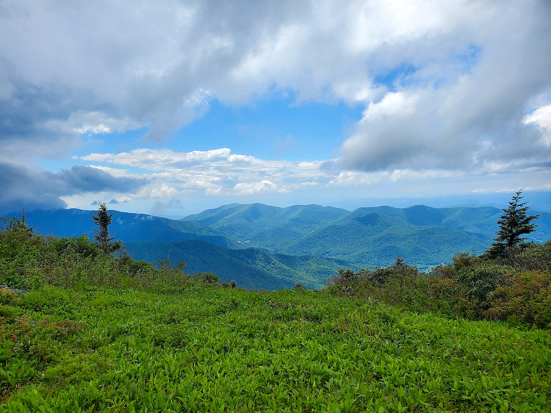
Once you make it to the ridge the view opens to a magnificent view of where you can see all the peaks you will touch on the rest of the hike. Words cannot explain the beauty of it, and you realize just how much all that uphill was worth it. I was expecting to make up some time on this section of the hike but that was not in the cards. I knew with all the peaks there was going to be a lot of up and down but what I was not expecting was the rock hopping. It became apparent real fast that I was going to have to scramble, climb, and shimmy around rocks while facing some drop-offs in sections.

Some places I needed both hands with not a good spot to set my tracking poles where they would not slide off the mountain. The wet conditions also made rocks a little slick and that slowed me down considerable. I came to a section where they placed a rope to help you climb and after shimmying around another rock then coming to another rope to climb down, I realized that I was not going to make this one.
I still had some distance before I would reach Deep Gap where I was planning to camp, then to get to Mount Mitchell and back to the car within the time I had allotted was just not going to happen. I decided to go back close to where I got to the ridgeline and camp for the night then make it back to the Jeep the next morning.
 |
 |
I setup my hammock and tarp and as I started to warm up water for my meal a real dense, wet, misty fog set in. I ate dinner had some tea and did not even try to start a fire. I retreated to my hammock, laid down, and listened to an audio book. As I finally started to drift off the wind pick up and it sounded like a jet engine above me all night. The wind would blow and then throw down all the moister that accumulated on the trees above me. It even shook the trees I was attached to.
In the morning when I woke up everything was just saturated. I did end up sleeping well as I was warm with the insulated pad and down sleeping bag. My body was never cold, but my hands froze with dampness from the equipment and the steady wind blowing through camp. I did not even try and make coffee I just packed and got started on the trail.

Downhill was faster but still not an easy hike with the wet leaves made everything slick. Made it back to the Jeep around 11:00 and started the drive back home. I did not even get close on this hike, but I was safe, and I got to spend time outdoors so that was a win in the end.
After thinking about this one the next time I try it again I need to get my pack weight down even more. Maybe just take a tarp, only take my cup and not a pot then cut town on some of my video/tech equipment. The other thing I will do is wait to fill up my water at the last creek stop about three miles up to cut down on the weight. Also, until I get the full scale of the whole trail, I will try to set up a shuttle and hike it only one way the next time. I still believe I can do a there and back, but I need to scout this out better.
YouTube Video:
Subject Links:
- Trail & Road Map of the Black Mountains.
- Pisgah National Forest.
- PNF - Black Mountain Crest Trail Info.
- Mount Mitchell State Park.
Follow My Other Adventures On My Website:


