Tuesday, February 14, 2017

Smoky Mountains – Anthony Creek


After a little debate with myself on the morning of January 15th I decided I could get this quick hike in before it got too late and hastily put together my pack and headed out. Saw this hike on the map several months ago, and had it marked for a nice half a day stroll when the time was right. The cold from the previous weekend had moved out and the temperature was setting right around 65 degrees so I did not need to pack much in the way of additional clothing. I was at the trailhead around noon and made my way up Lead Cove trail.

Start of Lead Cove Trail
Lead Cove is a winding trail that goes steadily up and gets your heart rate going just a bit but is not too overly hard at all. I think winter is the perfect time to hike this trail because without the leaves on the trees you can get the scope of the landscape and some areas you can view the mountains around you. In the summer with leaves you would not get those same sights.

Lead Cove Trail just before the Bote Mountain Junction
When I reached the Bote Mountain Trails it flattened out a bit and the dirt turned to more of sand. This section of the hike also had more rocks underfoot than Lead Cove did and made foot placement a bit hard at times. As far as aesthetics goes this was my least favorite trail I was on today. Just not much to see and if it wasn't for the fact the leaves were off the trees I would not have been able to see the mountain range to the side of me.

Bote Mountain Trail
Anthony Creek was the longest section of trail I was on and it was a very pleasant walk. It was nice to hear water running again in the park after a long dry summer and fall. There were several log bridge crossing and cascading water. I passed backcountry campsite #9 and have to say it looks really inviting. I think this spring it will be one of the first backcountry camping trips I plan this year. The trail itself was pretty rocky and a little hard on the old ankles.

Foot bridge along Anthony Creek
Crib Gap trail is a forest type trail that starts off really wide at the Anthony Creek junction but becomes more narrow as you go. It does cross Laurel Creek Road and it not well marked. The section of the hike north of Laurel Creek Road felt a little “bearish” and was hoping to see one but did not.

Anthony Creek
This is a very nice day hike loop and would recommend doing it in the winter when the leaves are off the trees, allowing for better views and less stagnant humidity.

Anthony Creek Trail & Crib Gap Trail Junctgion

Hike Details

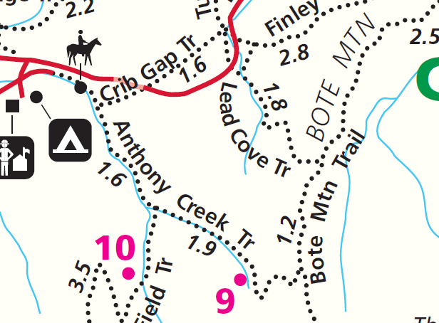
Hiked Section of Park Trail Map
Hike Date:
January 15, 2017

Start Time:
12:00 @ 65 Degrees F.

Finish Time:
16:35 @ 66 Degrees F.

Trails:
Lead Cove     1.8 Miles
Bote Mountain     1.2 Miles
Anthony Creek     3.5 Miles
Crib Gap      1.6Miles
     Turkeyden Ridge     0.2 Miles


Monday, February 6, 2017

Frozen Head State Park: Chimney Tops to Spicewood

Finally got some real snow down here in Tennessee on Thursday January the 6th and was really looking forward to going out to try all my new winter gear up in the mountains. Because of the snow and icy conditions the Smoky Mountain National Park decided to close all the roads so there was not any easy way to get into the park or to the trail I was looking forward to hiking. However this did finally give me an opportunity to look around to some of the State Park options here in Tennessee that I have been neglecting, so went up to Frozen Head State Park in Wartburg. 

While the altitude does not get much over 3,200 feet you still get a sense of being in the mountains. My friend and I decided to take the Chimney Top Trail which starts behind the visitor center when you first pull into the park. Starting out at an elevation of just around 1,400 feet you immediately climb up and down a mountain called "Love Mountain" only to start ascending Chimney Top Mountain without much of a break. The beginning is a lot of switch backs until you start getting close to the top of Chimney Top where it turns into a straight upward climb and finally starts to even out once on top of a ridge line. The incline on the way to the ridgeline is one of the steepest sections of mountain I have ever hiked. The wind had also moved snow in drifts so sometimes you had and half inch to an inch and at other times you were knee deep. This made it a little slower going.

The valley between Love & Chimney Top Mountains
         
The trails felt pretty narrow, but it was hard to tell for sure with all the snow on the ground. The snow also would have made it hard to stay on trail but as luck would have it someone got started before we did so there were footprints to follow and it was well marked with color blazes on the trees. Without leaves on the trees it was easy to make out the terrain and the prominent feature s large rocks and rock-outcrops. There seems to be a lot of streams or mountain runoffs too. Both of these are some of my favorite features in nature. 

After a small bite of lunch, we continued on until we made it to the Spicewood Trail where we decided to go ahead and loop back. While still seemingly narrow, this trail had a steadier decent for easier going. The only difficulty with this trail was a lot of small rocks made footing hard in places. With high precipitation this trail would have been harder as there are a lot more mountain runoffs crossing and at one point it actually felt as if the trail was a dried creek bed.

Summit of Chimney Top Mountain

I would have to say this hike has been one of the hardest if not the hardest I have been on so far. The rapid elevation gain and the up, down, up make it a fairly difficult hike. I am looking forward to doing this one in late spring, just to see what difference the snow made if any. I am also excited about trying out some of the other trails as well and would like to camp here over a weekend.

Trail Map of Frozen Head State Park


Hike Details

Hike Date:          January 6, 2017
Start Time:         8:30 @ 6 Degrees Fahrenheit
Finish Time:        14:30 @ 22 Degrees Fahrenheit
Trails:                 Chimney Top          6.00 Miles
                          Spicewood              2.55 Miles

         Links:                 Frozen Head State Park Website
                                   Full Size Trail Map

Laurel Falls via The Little Greenbrier

Smoky Mountain National Park Sunday, February 18, 2024 Like Laurel Falls, but do not like crowds? Well then this just might be the hike for ...