Friday, August 25, 2017

Smoky Mountains – Anthony Creek Overnight 


On Anthony Creek Trail heading towards Russell Field Trail
This adventure was my first solo overnight camping in the backcountry of the Great Smoky Mountains. Back in June of 2013 I did stay in the LeConte shelter with my friend but it wasn't a campground and it is quite a different feeling going into the wilderness overnight alone. With this being my first time I did make a few rookie mistakes which I have learned from and will hopefully correct on my next time out.

The first mistake was the hike I chose while still getting over a pretty nasty cold with an overfilled pack. It was a ten mile jaunt that had a high elevation gain, that I usually plan for but for some reason I did not research for this outing as it was somewhat of a last minute decision. However, when I am out I like to cover new ground and since just a month ago I hiked the other way off of the Anthony Creek trail I could not help myself and headed up the Russell Fields Trail. I had a late start while waiting for the morning rain to clear out and because of that and the steep climb I did not get as much time at camp as I wanted. In hind sight I should have went on a shorter hike and worked on my camp skills.

Heading up to the Appalachia Trail via Russell Field Trail
Of course my pack was heavier than it needed to be and not packed properly especially for a one night camp. I ended up with a lot of extra food that was not touched along with equipment that was never used. I also tried to pack everything in stuff sacks and I think it would have been better, especially with the clothes, to have squeezed them into the spaces between my other equipment. My cooking equipment should have been stored in the pack but I tried to carry that outside strapped to the back. The cooking equipment kept shifting around causing the bag to become unbalanced and I had to stop form time to time to tighten it.


Intersection of the Russell Field Trail and Appalachian Trail

Next time I need to be better prepared to get a fire started especially in wet conditions. I could get a flame going on a cotton ball with petroleum jelly but could not sustain it to catch the kindling. Probably bringing a piece of fire log or fat wood would help keep a flame until the wet stuff caught. While I did not have any problem setting up my hammock and tarp I did set the tarp up too high, which caused cold wind to blow over the top of me all night but my sleeping pad kept my backside warm.

There was still snow along the Appalachian Trail in the 
higher elevations.
The hike was a beautiful one that had some balds along the Appalachian Trail sections and took me through several different types of weather. It would have been much more enjoyable if I was still not somewhat suffering from the before mentioned cold that I had been fighting for three weeks. It had rained very early in the morning and did not stop till about 10:00 so I did not actually hit the trail until 10:30. It was cool and misty but once I hit the Russell Fields Trail Head the sun poked out and started to warm things up quite a bit. The sun was short lived and by the time I was about a mile or so out from the Appalachian Trail it started to rain again. Then as soon as I got to the Shelter at Russell Fields and the Appalachian Trail the rain turned to ice.

Hiking the Russell Field to Spence Field Section
of the Appalachian Trail
When I hit the A.T. there was still snow and ice in places and the trail itself was mud from all the melt and rain. At some places the mud was ankle deep and it made for some pretty slow going. On this section of trail there were places that had some actual grassy patches that I have not see in the Smoky Mountains all too often. These would make nice places to take a break if someone was through hiking the A.T. About half way through my section on the A.T. the sun came back out and warmed things up again and the blue sky made a stunning backdrop to the trees and grassy places along the trail.

Once I hit the Bote Mountain trail I was glad to have come up the way I had, because this section looked pretty steep. I ran in to a person coming up this trail and he looked winded from the incline and the thick mud. Since I was going downhill and had the late start I decided to pick up the pace in order to get to camp with some time before the sun went down behind the mountains.

At Anthony Creek Campsite #9


My home for the night at Campsite #9
The Anthony Creek Campsite was a beautiful spot tucked up alongside of the trail on one side and the creek on the other. There was a small waterfall that I could hear from my hammock to which gave me a ambient soundtrack to fall asleep to. After I got the hammock set up I had a type of a steak stew for dinner that I came up with a couple days before I set out. The night before I left cut up the steak and placed it in a Ziploc bag with some vegetable oil. Then I cut up onion, carrots, and celery and put that in a separate Ziploc back with vegetable oil. At camp I sautéed the vegetables and then added the steak to brown on all sides. Once I got the steak brown I added water and a beef bouillon cube and brought it to a boil then let it simmer for awhile. At the very end I added instant mash potatoes and for a backpacking meal it was great.

The next morning I planned on having breakfast but I was so cold from the overnight wind and all the wood was still wet so decided I would just pack up and go. Once I got going I warmed up and very much enjoyed the walk back to my car. I can say that I definitely want to hit this campsite again especially when it is a little warmer and I can get a fire going. For my first solo overnight it was a great experience.

Along Anthony Creek near Campsite #9
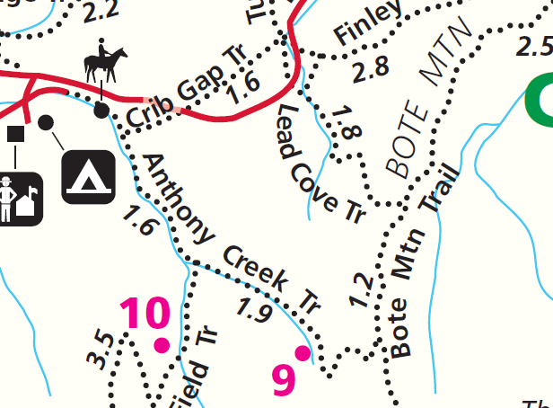
HIKE DETAILS

Hike Date:
March 18, 2017 – March 19, 2017

Weather:
Mixture of rain, ice & sun

Trails:
Crib Gap   0.25
Anthony Creek     1.6 
Russell Fields     3.5 
Appalachian Trail     2.9
Bote Mountain     1.7
Anthony Creek     3.5
Crib Gap    0.25

Thursday, March 23, 2017

Smoky Mountains - Mt. LeConte (Trillium Gap & Rainbow Falls)

This was the one. The hike I have been waiting to do since I moved down from Indiana over a year and a half ago. The hike I have been waiting to do since I climbed LeConte with my friend Greg back in June of 2013 for the first time. A winter hike up LeConte complete with snow, ice, and wind for what was a total adventure that did not disappoint. On January 29, 2017 I left the for the trail very early in the morning with the forecast of snow starting before noon. I parked at the Rainbow Falls / Trillium Gap trailhead with my headlamp on and started off in the dark.

Starting out on the trail early.
When I started hiking it was around 43 degrees so I started off just in a sweater and was plenty warm. There was not any snow yet on the ground and the headlamp gave the leafless trees long skinny shadows. As the sun rose and the headlamp came off I got to a section of forest that was hit hard by the Chimney Top 2 wildfire. This was my first experience with such a wide stretch of badly burned forest that the reality of the fire truly set in. It was amazing how the fire would leave spots untouched but then would totally burn another section out. There were also places where the under brush and/or ground cover was burned but the trees seemed not to have been touched. The whole thing felt very eerie.

A burn section along the Trillium Gap before the Grotto Falls parking lot.
Trillium Gap at this point basically follows Roaring Fork Mortor Nature Trail up until the Grotto Falls parking lot area where it breaks away and starts to really head up LeConte. This part of the hike was my least favorite when it came to views though you did get a good glimpse of LeConte but you will only get it when there are not any leaves on the trees. It does, however, really give you a perspective of the distance that needs to be covered to get to the top. Once I got to the Grotto Falls parking area I was on familiar ground having hiked this section of the trail many times up to the falls and to Brushy Mountain. It is always a nice walk and this was the first time I have been on it in the winter.

Ice forming on underneath the Grotto Falls.
By the time I got to Grotto Falls it was starting to get cooler and ice started to appear on the trial. I put on my microspikes when I got close to the falls and at this point they worked splendidly. There was a good volume of water running over the falls and it had started to form ice cycles underneath the rock outcropping. The sense of adventure always stirs when you walk behind the waterfall and in the winter with ice made it all the more invigorating at least for me. At this point of the hike I really felt like it is time to get down to business. During the busier touristy times of the year this is the spot on the trail everyone turns back but for me I feel like I am just getting started. I put on my stocking cap and made my way to the next landmark the Brushy Mountain / Trillium Gap junction.

Me at the Brushy Mountain & Trillium Gap junction just as it was starting to snow.
This was the fourth time I have been at this junction but the first time I stayed on Trillium Gap. The other times I have gone the other direction a short hike to Brushy Mountain that does have some fantastic views. I took a small water break and it was at this point the snow started to fall, light at first but then started to come down at a pretty good clip. I have said it before and I will say it again there is always a renewed sense of excitement when one takes their first steps on a new trail and it was with this feeling that I hiked on. My favorite environment in the Smoky Mountains is at the higher elevations where the pines and fur trees become prevalent. There is just something about that pine smell that appeals to me and when you add the snow on top of that I am truly in hiking heaven. This section of the trail got steeper and more icy so my pace got slower and slower. It was at this point I began to realize I may not have the time I need for everything I wanted to get in at the top of the mountain.

Snow along the upper portion of the Trillium Gap Trail.
As I closed in on the top of Leconte my legs really started to feel sore and knew it was about time for a nice break and some lunch, but decided to press on because of the time. Close to the summit along the trail there was a wire railing pinned into the rock face where running water had frozen to form basically a wall of ice. Nature always amazes and I feel privileged to be able to see such things. Around 13:15 I finally had made it to the top. I took some pictures around the Lodge and then made my way to the shelter to have some lunch. By this time the temperature had really dropped and I got fairly cold since I was no longer moving. I changed out of my sweater, put on my winter coat had lunch but decided I did not have time to spend taking pictures as I had wanted to do. My orginal plan was to have lunch and then visit the summit, Myrtle Point, and Cliff Top but the ice had really slowed me down and now I had to head down in slick conditions. I knew this was going to take some time.

A wall of ice along the upper portion of the Trillium Gap Trail.
I made my decent via the Rainbow Falls Trail which was the way I hiked up my first time back in June of 2013. The trail was fairly icy in spots but I had my microspikes. This is where I realized they did not quite work how I intended as snow would get in between the chain links and then compact. This basically turned the bottom of my boots into ice themselves. I was constantly banging the snow out of them on the way down as I would start to slide in spots that did not even have ice. Eventually I got into a rhythm and knew roughly when it was time to clean them out. Next winter I might have do a little more research and come up with a better pair. They worked well on just plain ice but when you added snow to the mix they became a little problematic.

Snow along the upper part of the Trillium Gap trail just before the Lodge.
On my way down I ran into the worst burn section that I saw all day. It was a large swath of land and appeared to have been mainly mountain Laurel and unlike the other places everything seemed to have been burnt from the ground up. At about 16:30 I ran into two hikers going up without true winter jackets, trekking poles, or spikes. They stopped and asked me about how much further it was to the top and at that point it was probably around two and half to two miles yet to go just to get to the top. They did not have any overnight equipment and it would be another six miles to get back down once they did get to the top. It always amazes me how many people are not really prepared for the hike they are going on especially in the winter conditions. I told them about how much further it was and we both continued on our ways. Apparently they must of thought better of it and passed me coming back down about ten minutes later.

A frozen Rainbow Falls.
I reached Rainbow Falls just  after 17:00 and stopped to take a few pictures. It was a tad bit warmer at the lower elevation and the snow had become heavy and wet. Just as I took my last picture there was a drastic change in light when the sun had gone down behind the mountain. I had about two and half miles left until the parking lot and made my way down as fast as I could. I feel that I am in above average shape, but this hike really pushed my endurance level due to the snowy and icy conditions. There was less ice at the lower elevation and I was able to take the spikes off and make better time. With just under a mile left I had to get my headlamp out and started dealing with snow, fog, and now darkness. Staying on trail became somewhat of a challenge but I was able to manage. I made it back to my car around 18:30 and thus ended my Mt. LeConte winter adventure. Next time I want to try and spend the night at the top so I have time to hit all the views and summit. I really wish I would have gotten to take a picture at the summit as it would of the perfect addition to the perfect day.


HIKE DETAILS

Hike Date:
January 29, 2017

Start Time:
6:30 @ 43 Degrees F.

Finish Time:
19:00 @ 32 Degrees F.

Trails:
Trillium Gap            8.80 Miles
Rainbow Falls          6.00 Miles

Tuesday, February 14, 2017

Smoky Mountains – Anthony Creek


After a little debate with myself on the morning of January 15th I decided I could get this quick hike in before it got too late and hastily put together my pack and headed out. Saw this hike on the map several months ago, and had it marked for a nice half a day stroll when the time was right. The cold from the previous weekend had moved out and the temperature was setting right around 65 degrees so I did not need to pack much in the way of additional clothing. I was at the trailhead around noon and made my way up Lead Cove trail.

Start of Lead Cove Trail
Lead Cove is a winding trail that goes steadily up and gets your heart rate going just a bit but is not too overly hard at all. I think winter is the perfect time to hike this trail because without the leaves on the trees you can get the scope of the landscape and some areas you can view the mountains around you. In the summer with leaves you would not get those same sights.

Lead Cove Trail just before the Bote Mountain Junction
When I reached the Bote Mountain Trails it flattened out a bit and the dirt turned to more of sand. This section of the hike also had more rocks underfoot than Lead Cove did and made foot placement a bit hard at times. As far as aesthetics goes this was my least favorite trail I was on today. Just not much to see and if it wasn't for the fact the leaves were off the trees I would not have been able to see the mountain range to the side of me.

Bote Mountain Trail
Anthony Creek was the longest section of trail I was on and it was a very pleasant walk. It was nice to hear water running again in the park after a long dry summer and fall. There were several log bridge crossing and cascading water. I passed backcountry campsite #9 and have to say it looks really inviting. I think this spring it will be one of the first backcountry camping trips I plan this year. The trail itself was pretty rocky and a little hard on the old ankles.

Foot bridge along Anthony Creek
Crib Gap trail is a forest type trail that starts off really wide at the Anthony Creek junction but becomes more narrow as you go. It does cross Laurel Creek Road and it not well marked. The section of the hike north of Laurel Creek Road felt a little “bearish” and was hoping to see one but did not.

Anthony Creek
This is a very nice day hike loop and would recommend doing it in the winter when the leaves are off the trees, allowing for better views and less stagnant humidity.

Anthony Creek Trail & Crib Gap Trail Junctgion

Hike Details

Hiked Section of Park Trail Map
Hike Date:
January 15, 2017

Start Time:
12:00 @ 65 Degrees F.

Finish Time:
16:35 @ 66 Degrees F.

Trails:
Lead Cove     1.8 Miles
Bote Mountain     1.2 Miles
Anthony Creek     3.5 Miles
Crib Gap      1.6Miles
     Turkeyden Ridge     0.2 Miles


Monday, February 6, 2017

Frozen Head State Park: Chimney Tops to Spicewood

Finally got some real snow down here in Tennessee on Thursday January the 6th and was really looking forward to going out to try all my new winter gear up in the mountains. Because of the snow and icy conditions the Smoky Mountain National Park decided to close all the roads so there was not any easy way to get into the park or to the trail I was looking forward to hiking. However this did finally give me an opportunity to look around to some of the State Park options here in Tennessee that I have been neglecting, so went up to Frozen Head State Park in Wartburg. 

While the altitude does not get much over 3,200 feet you still get a sense of being in the mountains. My friend and I decided to take the Chimney Top Trail which starts behind the visitor center when you first pull into the park. Starting out at an elevation of just around 1,400 feet you immediately climb up and down a mountain called "Love Mountain" only to start ascending Chimney Top Mountain without much of a break. The beginning is a lot of switch backs until you start getting close to the top of Chimney Top where it turns into a straight upward climb and finally starts to even out once on top of a ridge line. The incline on the way to the ridgeline is one of the steepest sections of mountain I have ever hiked. The wind had also moved snow in drifts so sometimes you had and half inch to an inch and at other times you were knee deep. This made it a little slower going.

The valley between Love & Chimney Top Mountains
         
The trails felt pretty narrow, but it was hard to tell for sure with all the snow on the ground. The snow also would have made it hard to stay on trail but as luck would have it someone got started before we did so there were footprints to follow and it was well marked with color blazes on the trees. Without leaves on the trees it was easy to make out the terrain and the prominent feature s large rocks and rock-outcrops. There seems to be a lot of streams or mountain runoffs too. Both of these are some of my favorite features in nature. 

After a small bite of lunch, we continued on until we made it to the Spicewood Trail where we decided to go ahead and loop back. While still seemingly narrow, this trail had a steadier decent for easier going. The only difficulty with this trail was a lot of small rocks made footing hard in places. With high precipitation this trail would have been harder as there are a lot more mountain runoffs crossing and at one point it actually felt as if the trail was a dried creek bed.

Summit of Chimney Top Mountain

I would have to say this hike has been one of the hardest if not the hardest I have been on so far. The rapid elevation gain and the up, down, up make it a fairly difficult hike. I am looking forward to doing this one in late spring, just to see what difference the snow made if any. I am also excited about trying out some of the other trails as well and would like to camp here over a weekend.

Trail Map of Frozen Head State Park


Hike Details

Hike Date:          January 6, 2017
Start Time:         8:30 @ 6 Degrees Fahrenheit
Finish Time:        14:30 @ 22 Degrees Fahrenheit
Trails:                 Chimney Top          6.00 Miles
                          Spicewood              2.55 Miles

         Links:                 Frozen Head State Park Website
                                   Full Size Trail Map

Laurel Falls via The Little Greenbrier

Smoky Mountain National Park Sunday, February 18, 2024 Like Laurel Falls, but do not like crowds? Well then this just might be the hike for ...